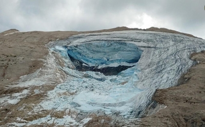
Guwahati, Jan 27 (IANS) Researchers from the Indian Institute of Technology (IIT) Guwahati have developed a predictive framework that has identified 492 locations where glacial lakes are likely to form in the Eastern Himalayan mountains.
The research conducted using high-resolution Google Earth images and digital elevation models also provides crucial insights for hazard management and water-resource planning in high-mountain regions.
The models helped capture complex landscape features and estimate uncertainty in the predictions, making the forecasts more realistic and reliable.
With the developed framework, the research team identified 492 locations in the Eastern Himalaya where new glacial lakes are likely to form, thereby indicating areas that require careful monitoring and preventive measures.
“By pinpointing high-risk areas, the framework can guide early-warning systems for Glacial Lake Outburst Floods (GLOFs), help plan safer locations for roads, hydropower projects, and settlements, and support long-term water-resource management. It offers a practical tool for reducing risks to communities and infrastructure in the Himalayas,” said Prof. Ajay Dashora, Assistant Professor, Department of Civil Engineering, IIT Guwahati.
“Beyond hazard management, the method can help understand how water systems may change as glaciers continue to retreat. Importantly, the framework is adaptable to other glaciated mountain regions around the world, making it a valuable tool for climate-resilient planning and disaster-risk reduction globally,” Dashora added.
The findings, published in Nature’s Scientific Reports journal, confirm that the shape and structure of the land, often overlooked in previous studies, can play a central role in where and how a glacial lake may appear.
In the development process, the research team tested three predictive methods, including Logistic Regression (LR), Artificial Neural Network (ANN), and Bayesian Neural Network (BNN)
Among these, the research team found the Bayesian Neural Network (BNN) to be the most accurate and showed that certain earth features, such as neighbouring lakes, cirques, gentle slopes, and retreating glaciers, are the strongest predictors of glacial lake formation.
The team now plans to integrate moraine development histories, automate data preparation, and add field-based validation to the developed framework.
These improvements will enhance the model’s accuracy and broaden its use for large-scale monitoring of glacial hazards.
--IANS
rvt/